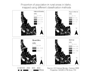
The first figure is my original set of maps showing the proportion of the population of regions in Idaho living in rural areas, displayed using several different classification schemes. The second figure is my edited version of these maps. One change I made was changing the labeling at the top of the legend on each map from “Rural Population” to the name of the classification method being used for that map; therefore the audience has a way to tell which map uses which classification scheme. Also I moved the scale bar and credits towards the center to make the map look more organized, and finally I added a title to the set of maps.


No comments:
Post a Comment